top of page
If you don't take full & sole responsibility
for your (dependents') use of information
associated with this site, don't (let them) use it.
How Trail Ratings are Determined
Created: 2020jul05sun
Updated: 2024may01wed
Intro
Two major factors to consider before attempting a trail, is (1) the physical exertion required by, and (2) the danger associated with the trail. The same danger becomes much more significant under greater exertion, due to reduced movement-control when muscles become fatigued.
Required exertion can be determined in terms of maximum or average measurements of the physical, geometrical attributes of a trail taken in total over its entirety. Associated danger can be determined in terms of similar, but specific measurements taken over the single most-extreme section of a trail.
Required exertion can be calculated quantitatively in terms of maximum altitude, total distance, and total ascent. Associated danger can be calculated in terms of maximum angles of elevation and depression and the respective specific slope-lengths. Associated danger can also be expressed in terms of a subjective, qualitative measurement-scale.
Due to the differences in concept and scope-of-measurement between required exertion and associated danger, as well as the lack of an objective and clear, quantifiable, mathematical relationship between them, they cannot be combined in a single trail-rating formula, but must be considered separately.
Other measurements and calculations, such as total time, walking time, rest time, speed and climb rate, all depend subjectively on the physical fitness, skill, strength and stamina, as well as the mental drive, focus, perseverance and patience of the individual hiker and/or the group dynamics, and also ever-changing weather-conditions on the day. Therefore, these performance factors do not objectively reflect the independent, geometrical and physical conditions of the trail itself, and differ from hike to hike, even for the same hiker on the same trail.
Required Exertion
Maximum Altitude
"Vensterberg"/Geelhoutboomberg (1242m), "Outeniqua View" (1310m), Sleeping Beauty (1264m), George Peak (1337m), Cradock Peak (1560m) and Formosa Peak (1675m) in the Southern Cape/Garden Route region of South Africa may be classified as either approaching or being "high altitude" mountains, 1500-3500m above sea level. At higher altitude, the atmosphere has a lower oxygen-concentration than at sea level. At around 1500m above sea level, the mild effects of acute mountain sickness (AMS), which is the mildest form of altitude sickness, may begin to manifest due to the high degree of activity, and the rapid increase in elevation during mountain hiking/climbing. AMS may manifest at different altitudes for different hikers. Being physically fit does not decrease the risk.
Headaches, shortness of breath upon exertion, hyperventilation, "pins and needles"/tingling, fatigue, lightheadedness, dizziness, nausea and slight swelling of extremities have all been reported anecdotally and/or experienced independently, to greater or lesser degrees, on the climbs to George and Cradock Peaks. It is recommended that, at high altitude, these symptoms be assumed to indicate AMS.
Treatment usually involves taking sufficient liquids, and descending to lower altitudes again. This is usually done within a reasonably short time in any case so that maximum altitude is usually merely a factor contributing to required exertion more than it does to any significant level of associated danger.
Although total ascent might be a more popular, common and better measure of required exertion, the same elevation gain at altitude requires significantly greater exertion. Therefore, altitude itself does also play a role to determine exertion.
Although quite a number of mountains in the Drakensberg approach the lower limit of the "very high altitude" region, no mountain in South Africa actually exceeds that limit of 3500m above sea level.
Total Distance
What it says on the label. However, in the Garden Route, distance is considered to be a more significant indicator of exertion than altitude, since the altitudes are still relatively low.
Total Ascent
Total ascent, measured in metres, gives a measure of the total upward-climbing required on a trail, and an indication of required exertion. It should not be confused with maximum altitude. Total ascent can be considered as the total vertical distance that was only climbed upwards on any trail, ignoring any down climbs. This results in total ascent usually exceeding maximum altitude. Although most trails have some upward sections alternating with some downward sections, some trails have a greater total ascent than descent going in one direction along the trail than going in the opposite direction.
Associated Danger
Maximum Angles of Elevation & Depression and
Specific Slope-Lengths
Maximum angles of elevation and depression (gradient, grade, inclination, slope, or steepness), expressed in degrees (or percentages, or rise/run ratios), give a measure of the associated danger of the most extreme uphill and downhill sections of a trail, respectively. The length of the slope is also a factor to consider in determining the risk in each case.
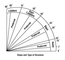
An angle of 0 degrees is "flat", 90 degrees is a "wall". Angles less than 50 degrees might be considered to be "stairs" at most. Angles greater than 50 degrees might require the use of hands as well, upper-body-strength and/or other, further assistance. Angles of 50-75 degrees might be considered to be "scrambles" rather than "walks". Angles greater than 75 degrees might be considered to be "climbs".
The angle of a certain extreme-section of a trail may be reduced by zigzagging diagonally across that section, if possible, in stead of traversing it vertically up or down. However, this increases the length of the slope, and does not necessarily reduce the risk of falling, but might increase the level of ease of the climb.
A 90-degree angle with a 0.25m slope-length is simply a single stair-step. Therefore, only obstacles with slope lengths greater than about 1m are considered, where upper-body strength and/or assistance might be required. Furthermore, consideration is given to the question of whether a steeper up-climb might be more dangerous than a flatter down-climb, or not. Also, a 30-degree angle requires twice the slope length to achieve the same elevation-gain as a 90-degree angle.
Moreover, a there-only trail might have an average, straight-line angle, between its start and end points, of 30 degrees over its entire distance, but there might be significant climbing-sections along the way, which could prove impassable for some hikers.
On the other hand, such impassable obstacles might be of lesser concern on a there-and-back trail than on a circular/there-only trail. On a there-and-back, hikers may wait at the obstacle for the rest of the group to return. Therefore, there-and-back trails might generally be considered to be safer than circular/there-only trails.
Lastly, the difference in difficulty between a down scramble and a down climb is much more significant than that between an up scramble and an up climb. Although a down scramble requires less exertion than an up scramble, a down climb requires significantly greater technical climbing-expertise than an up climb, because of a less-favourable visual angle and/or a possibly-uncomfortable relative body-orientation. A down gradient is indicated by a negative value, below the 0-degree horizontal.
According to a subjective estimate, a 65-degree down-scramble, on which a hiker will probably rather want to sit down in stead of attempt to walk it down upright, might compare to an 80 degree up-climb. This indicates that a down climb might be weighted approximately 1.25 times more than an up climb of equal gradient. It seems fair to compare a 90 degree down-climb with a 112.5-degree overhang up-climb, requiring not insignificant climbing-expertise.
Qualitative Danger
Qualitative danger refers to a subjective evaluation, on a scale from 0 to 5, of the most extreme conditions on a trail in terms of obstacle difficulty, recurrence, and the severity of possible injury. This involves factors such as side-by-side strolling, single-file queuing, bundu bashing/bushwhacking, rock hopping, slipperiness, river crossings, rock scrambling and climbing, cliffs, precipices, etc., the frequency of such obstacles along the trail, and ease of access for search-and-rescue teams.
A value of 5 indicates the greatest danger, comparable to that of the obstacle course along the Glentana-Herolds Bay coast between Cape Windlass and Maalgate Mouth. Fractional values may also be used. No trail, no matter how broad, level, flat and straight, can have a qualitative-danger measure of absolute 0, since there is always the possibility of tripping over one's own feet.
Putting it All Together
Ordered Trail List
Since it is the extreme obstacles that present the most difficulty for hikers, the sortable and searchable "Trail Ratings.ods" spreadsheet, downloadable from the "Trails" homepage of this site, includes only the most extreme data from each trail.
The spreadsheet converts all data for a specific aspect down a column (e.g. maximum altitude, total distance, etc.) to relative measures out of 100 for all the trails listed. Then it calculates appropriate weighted arithemtic-means of these relative measures for all aspects along a row for any particular trail.
Since the trail ratings for required exertion and associated danger are the two weighted arithmetic-means calculated from relative measures out of 100, the two trail ratings themselves are also calculated on a scale from 0 to 100. Higher values indicate greater required exertion or associated danger.
The spreadsheet assigns weights to the following aspects in the following ratios for the calculation of the required exertion and associated danger trail-ratings.
Required Exertion:
maximum altitude 1
total distance 2
total ascent 4
Associated Danger:
maximum elevation angle 1
specific elevation slope-length 1
maximum depression angle 1.25
specific depression slope-length 1
qualitative danger 1
Angles are measured relative to a maximum of 90 degrees.
These weighting ratios (and maximum angles) are determined according to the subjectively-perceived significance-of-effect of their respective constituent terms and factors in the respective formulae, and may be edited in the spreadsheet.
Therefore, with complete and accurate measurement-data, there should only be four subjective/relative aspects to these formulae, i.e. (1) the fact that the method of a weighted arithmetic-mean was chosen in the first place, in stead of another formula, (2) the weight ratios themselves used in the formulae, (3) the qualitative-danger evaluation, and (4) the fact that most of the relative measures are merely determined relative to the maximum data-value collected for that variable among the hiking trails listed in the spreadsheet.
The weighted arithmetic-mean method was chosen merely for its relative simplicity in calculation, as well as for its at-least seeming applicability. The other subjective aspects are even much more poorly defined, being based simply on a personal gut-feel from some vague memories of some relatively limited experiences.
Although the subjectivity of the these stated aspects is hopefully better balanced by the relative comprehensiveness of the objective data used than for other trail-rating systems and formulae, the incalculable amount of subjectivity that still remains in the calculation of these two trail-ratings, is still significant. Therefore, these required exertion and associated danger trail-ratings should not be taken to represent any kind of objective/absolute measures at all whatsoever.
Besides, since a hiker can only ever assess a trail for themselves, and express that assessment relative to their own subjective memories of other trails that they might have done before, trail ratings should perhaps also rather attempt to agree as closely as possible with this natural, inherently-human relativity, than try to present some indeterminably-artificial, mechanistic, absolute quantification.
The Shenandoah Hiking-Difficulty Formula employs a single, unexplained, modified geometric-mean of merely total distance and total ascent, and admits to being an imperfect, approximate indication of difficulty. The Colorado Hike-Difficulty Calculator has novice and expert-hiker settings, and seems to use some form of a single, distance-vs.-total-ascent linear formula. Also, the single number generated by the Northwest Hiker Hike-Difficulty Calculator is also merely based upon distance and total ascent only. The subreddit r/hiking also has some discussion on this topic. Trail Hiking Australia has a related discussion regarding the Council of Bushwalking Australia's Australian Walking Track Grading System (AWTGS). The local Berg-en-Dal Hiking Club's Trail Grading System offers a "Numeric value" that is supposedly "calculated", but after emailing their secretary on 2024jan23tue, requesting some insight into their formula for this supposed "calculation", I am still awaiting an answer.
It is hoped that these two weighted arithmetic-means presented on this website, represent an improvement on these and other example formulae and subjective systems cited here, at least in terms of the comprehensiveness of the objective data used.
At the moment, while all the data in the spreadsheet have not yet been confirmed by means of consistent, accurate, first-hand measurements on an adequate GPS device, the data collected from sources such as the Berg-en-Dal Hiking Club's route summary, as well as the Esri/Imagery Western Cape topographical map in conjunction with Google Maps have been used instead. Also, at the moment, some elevation and depression angle and specific slope-length data have merely been guesstimated from vague, personal memory.
The spreadsheet already contains copied formulae for 1000 trail entries. Entering the appropriate data after the last complete entry in the spreadsheet, will automatically generate the weighted arithmetic-mean trail ratings for the required exertion and associated danger of any trail that might not be included in the spreadsheet already. Editing the weight values at the top of each of the relative-measure (RM) columns, will affect the final trail-rating calculations. Re-sorting the spreadsheet, will arrange the new trail relative to the existing trails.
Suggestions
For me, scrambling and climbing is probably some of the most fun I could possibly ever have on a hike. Solving a nice climbing problem gracefully, is like solving a tricky Maths problem elegantly. I'm wholeheartedly convinced that climbing and Maths employ the same mental mechanisms. No amount of argumentation will convince me otherwise.
...walkwherewaterwould...
find the lines
and flow with them -
the ground will whisper where(;)
to go with them
On the one hand, if Carl can climb blind with some sighted guidance, then it's not actually all as hard as what it might seem. On the other hand, just because Carl could climb blind with some sighted guidance, doesn't mean that it's easy for everyone either. For crying out loud, just, please... climb responsibly!
Also, having done it myself, and having tested it with friends (videos will be posted someday), I'm very strongly of the opinion that climbing blind is easier than climbing sighted.
I seriously want to prove this on camera one day as well, at the Glentana Crawl Space, by myself being guided by an indemnified, willing, sighted hiker who has never done the Crawl Space before, and by similarly guiding such a blindfolded hiker myself as well. I've taken Carl through the Crawl Space, but he's used to being blind. My purpose is to prove that sighted people can benefit in such a situation from being temporarily blindfolded.
If you think that such an experiment would be irresponsible, then consider (1) my own high regard for, and continual emphasis on practicing safety responsibly, and (2) your own lack of experience climbing blind.
You don't have to trust me if you don't want to. I'm not going to force you to do anything against your will. ...But, as long as you've never really done it yourself, you can't really know what it's all about either. So, keep on talking. I'm not listening. Your emotional reaction is preventing you from seeing what is right there in front of your nose. ...literally and figuratively applicable to this scenario on all levels; all puns intended.
...But if you can't even climb properly without a blindfold, then don't try to do it with a blindfold without the assistance of someone who can actually climb properly. Don't be stupid about this.
Workflow
The following is more of a reminder for myself for the purposes of attempting to remember how to streamline the workflow of collating the GPS data, and extracting the relevant information, in a consistently-comparable manner, but it does also indicate where and how I get my information. Any suggestions for improvement will be greatly appreciated.
1. As soon as possible after a hike, plug the Garmin eTrex 22x into the laptop, and transfer the .gpx track and waypoint files to the relevant route's GPX folder on the internal HDD, and change the filenames to indicate "01 Trail/Route original" .gpx files. Keep filenames simple, but numbered in order; no need for dates to be included.
2. Next day, download pics and vids from WhatsApp etc., one uploader at a time, in order to keep track of who uploaded what. Delete unwanted WhatsApp pics and vids.
* *
Processing:
3. Day 1: Shotcut: put GoPro video-clips together, cutting irrelevant sections, cross-fading across cuts in a clip, fading video and audio in and out at the start and end of every clip, zooming, muting, and adding text notes as necessary. Add videoblackground.png at the start and end, for intro notes and outtro screen, and stretch to 20sec each.
4. Day 2: In Shotcut, add the best in to the appropriate locations, fading video in and out at the start and end of pics and vids, assigning applicable credit. Watch the video through, checking added effects. Render the video; it usually takes between one to two times as long as what the video itself is. Run through rendered .mp4 again, checking integrity and consistency.
* *
5. Day 3: Upload to YouTube (qdothikes); this can take about a day. Details: Title "YYYYmonDDwkd Trail/Route"; Add Shotcut chapter-timestamps to description; Select playlists; Show More: edit tags, indicate recording date and location. Video elements: Add end screen, import from latest video; Add cards: video (if available), channels: Karl &/ Carl (if applicable). Visibility: Public.
*
While uploading to YouTube (qdothikes):
6. PlotARoute: upload (and edit) "01 Trail/Route original" .gpx. No need to sign in.
Record Total Distance. If the track contains more than 2,500 trackpoints, split it into shorter sections, saving each section separately. (Download the "02 Trail/Route (un)edited part #" .gpx file(s) in the relevant route's GPX folder on the HDD.)
7. GPS Visualizer: Combine (separate) "02 Trail/Route (un)edited" (sections) and "01 Trail/Route original waypoints" into a single, "Trail/Route" .gpx file.
8. GPS Visualizer: convert "Trail/Route" .gpx to "Trail/Route" .txt, and analyse in spreadsheet.
Save the "Trail/Route" .txt file in the relevant route's GPX folder on the HDD.
The following selections have already been included in the bookmark hyperlink to GPX Visualiser. Add estimated fields: slope (%) and distance. Add DEM elevation data: best available source. Show advanced options. Trackpoint distance threshold: 5. Show track statistics (distance, time, elevation): yes. Calculate elevation gain: Yes. Elevation gain/loss threshold: 5. Time offset: +2.
Use TRACK STATISTICS (on the right of the output window) to record: Max Elevation (Altitude), and Elevation Gain/Loss (Total Ascent).
Spreadsheet Analysis
Open the "Trail/Route" .txt file in a LibreOffice Calc spreadsheet: Unicode (UTF-8), Default - English (USA), From row: 1, Separated by: Tab, Detect special numbers.
Determine: Max Elev/Depr-Angles, and Associated Slope Lengths from "Trail/Route" .txt. Associated Slope Lengths are calculated by subtracting the first total-distance measurement after the relevant section minus the first total-distance measurement before the relevant section (because the slope stretches between those points, across the points measured in-between).
9. Upload the "Trail/Route" .gpx file to mymaps.google.com (qdothikes), and edit appropriately. (Map title: "Trail/Route", Description: "https://walkwater.wixsite.com/wwww"; Scroll to bottom of Layers box. Base map > Satellite; Zoom appropriately; Map title menu > Set default view / to see previous maps, map title menu > new map; map title menu > move to bin) [Wikiloc cannot handle PlotARoute segments combined by GPS Visualizer.]
10. Update the Trail Ratings.ods spreadsheet with the new data.
11. Wix: Upload "Trail/Route" .gpx file. Delete old Trail Ratings.ods. Empty media-file trash. Upload new Trail Ratings.ods. | Create wixpage. Create hyperlink to "Trail/Route" .gpx file on the wixpage. Change video: copy link to YouTube even though it's not completed loading yet. | Trails homepage: create wixpage hyperlink, and update Trail Ratings.ods hyperlink. Publish.
*
12. YouTube: Details: Select thumbnail (after SD has finished processing). Visibility: Publish; then Rearrange playlists.
13. Internal HDD: Delete all files, except final .mp4, and move it from internal to external HDD backup.
bottom of page